Up and Down: Maryland Weather at its Finest

Mark Townsend, Agriculture Agent Associate | mtownsen@umd.edu
University of Maryland Extension, Frederick County

It feels that most years we find ourselves finding something abnormal about the weather. This year is no exception and in some ways is even more different from our “abnormal-normal.”

Put lightly, the 2022-2023 winter was mild. There were only a handful of instances where we fell significantly below freezing and stayed there for more than a night or two. In fact, the average temperature from January to March of 2023 of 43.4 degrees Fahrenheit, was the second warmest on record in the 128-year NOAA Statewide Time Series dataset, just falling behind 2012 at 43.5 degrees Fahrenheit.

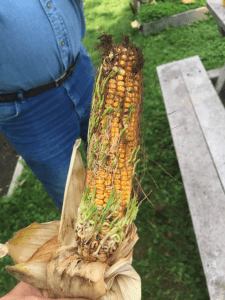
With this comes a significant accumulation of Growing Degree Days (GDD), a heuristic tool measuring the accumulation of heat through time which can be used to predict the development of crops and insects during the growing season. For review, GDDs are calculated by taking a simple average of the high and low daily temperatures subtracted from some base level. The base level is determined for each crop representing the lowest temperature the plant may still develop. For wheat and other small grains, the base temperature is often 32 or 40°F, while warm season crops like corn and soybeans have a GDD base temperature of 50°F.

Figure 1 is a cumulative line chart illustrating the accumulation of growing degree days since the start of the year in Frederick, MD. These data were obtained from the Cornell Climate Smart Farming (CSF) Growing Degree Day Calculator measured at a Frederick County, MD location, and a base temperature of 50 degrees (corn/soybeans base).

Figure 1. Growing Degree Day chart, Base 50, for Jan-May 2023.

The chart illustrates the significant accumulation of GDDs in the last three months with the green line-and-dot figure poised well above the 15 year and 30-year averages. Of note is the rapid accumulation of GDDs in early to mid-April–illustrated by the rather large upward slope in a relative short period of time. Though we have not set any records, illustrated by the gray-bands above and below the data, we certainly came close in mid-April. This run-up coincided with abnormally dry conditions as well.

On the precipitation front, the region has generally been below average coming out of the winter months. Data from NASCE Prism Climate Group at Oregon State and USDA RMA (Figure 2) illustrates the precipitation anomaly, or difference in rainfall compared to the average from January to March for the continental US.

Figure 2. Percent deviation of average precipitation.

We may observe how the Mid-Atlantic held a range from 50-70% of average rainfall for the time period ending on March 31st.

The saying, “April showers bring May flowers” generally holds true in Maryland: on average and depending on the region in Maryland, we receive 3-5” of rainfall in April. This year, much of the region did not receive significant precipitation from April 1st to April 21st. Other regions only had to hold out another week to April 27th -28th to finally quench their thirst. These much-needed rains have brought much of the region at or near seasonal averages–bittersweet news for some crops that were in the rapid-development stage during the dry-period and for others that were “dusted-in” (planted into dry soil) in mid-April.

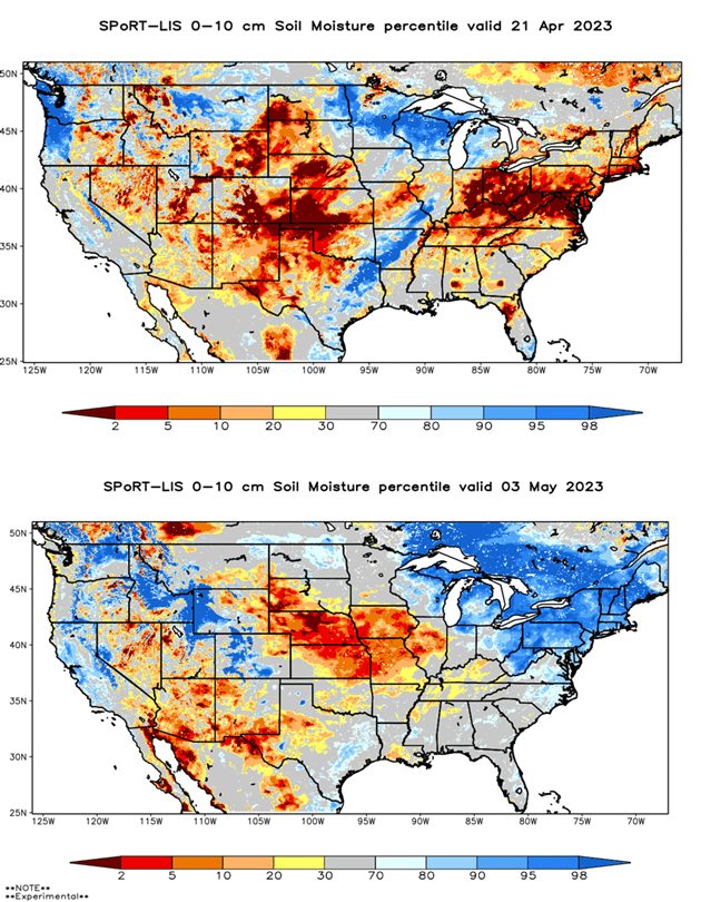
Speaking of; soil moisture has obviously reflected precipitation trends. Figure 3 are NASA Soil Moisture models based on satellite data. Figure 3 shows the model before our first rain on April 21st, while Figure 4 is the most recent model at the time of writing. We may observe how drastic the change in soil moisture has been in the last two to three weeks moving from a significant deficit (red areas, Figure 3) to nearly oversaturation (darker blue areas, Figure 4).

Figure 3 (top) & 4 (bottom). Soil moisture percentile thru April 21, 2023 (top) and thru May 3, 2023.(bottom).

Though we have received much needed rainfall it has come at the expense of temperature and GDD accumulation. Looking back at Figure 1, we have leveled-off significantly in accumulation rate in the last few weeks of April and into May, and are approaching the 15 and 30 averages.  Additionally, data from the Northeast Regional Climate Center (Figure 5 & 6) illustrate the GDD Difference from last year for the Mid-Atlantic and Northeastern United States by county modeled at 4/21 and 5/3, respectively.

Figure 5 (top) and 6 (bottom) . Growing Degree Day differences from average, March thru May 2023.

The comparison of the charts again yields useful information indicating that we were about 10-14 days ahead of last year and 7-10 days ahead of the average on 4/21. The cool temperatures much of the region has felt has made up this difference as we sit about 3-10 days ahead of last year with generally little difference on average.

In terms of agronomics, there are many potential takeaways that one can derive from these observations. Though generally speaking, it may be useful to begin scouting for diseases in small-grain crops especially as we move into reproductive phases of crop development paired with the recent spell of cooler, wet weather. Though we may be outside of the typical window, powdery mildew tends to propagate well in these conditions; and though previous fusarium head-blight models have not indicated a potential concern, this has changed given recent cool, wet weather patterns. Pre and post-emergent damping off pathogens, such as Fusarium, Rhizoctonia, and Phythium, are also a concern under cool, damp soil conditions and can affect seedling stands of both corn and soybean, especially on non-treated seed. In any event, keeping-tabs on crop conditions during this period is generally best practice.

Similarly, it may prove useful to scout seedling crops for root damage from cool, wet weather loving pests like seedcorn maggot, wireworms, white grubs, corn rootworm, and slug. Additionally, a “flag-test” may be worthy to assess emergence of recently planted crops as germinating seed may be weakened by imbibing colder soil water.

Though as gloomy as looking back on recent weather may be, it does appear that drier and warmer weather is in the immediate forecast. Here’s to May flowers!

Maryland Regional Crop Reports: May 2022

Western Maryland

Erratic weather patterns continue to dominate and challenge us here in Washington County. While we can still use precipitation, it has recently been coupled with wild temperature swings. In the 70s or low 80s and then back to the low fifties with nighttime temperatures on several occasions hovering near freezing. Triticale harvest is over half finished but very little corn has gone in the ground. First cutting alfalfa will begin early next week barring rain showers. First cutting hay of any kind looks like it will be below normal. Forever the optimist, second cutting will be better.—Jeff Semler, Washington Co.

Central Maryland

Small grain silage harvest is in full swing. Manure is being hauled and corn is being planted. Some soybeans have been planted. First cutting of hay may also start soon. Over the past month, most of the area has been at or above normal rainfall, according to the National Weather Service. Field work may slow down depending on much rain we get this weekend, but next week is forecasted to be drier and in the 70s. —Kelly Nichols, Montgomery Co.

Northern Maryland

The trend for April has been a continuation of March—cool temperatures that rarely want to move out of the 60s. As a result, the start of planting was about a 5-10 days later than usual for this region. Most planting kicked off the week of Easter. In general, small grains look good. Barley is headed out and wheat is a couple of weeks away. Some rye has been chopped for feed. Pastures and hay fields are enjoying the cooler temperatures.—Andy Kness, Harford Co.

Upper & Mid Shore

Soil moisture has been perfect for spring crops, field work, and planting. Soil temperatures have been a little cool for this time of year. Many acres of corn and beans have went in over the past week. Barley is fully headed and wheat will be in a few days. Both look good. Hay and pastures look good, but the cool weather has them a little behind normal.—Jim Lewis, Caroline Co.

Lower Eastern Shore

Wheat is starting to pollinate. It’s been a relatively dry spring, making for an average to above average wheat crop, with minimal disease pressure. Cover crops have been mostly terminated. However, where still standing, cover crops are looking great. These late-terminated cover crops should bring additional benefits to the fields, such as providing substantial organic matter to the soil, and in some cases releasing nitrogen on the soil surface. Growers have spread poultry manure. Weather has been relatively favorable these last couple of weeks for planting. Corn has started to be planted. Much more corn acreage is expected to be planted in the next weeks, to be followed by soybean planting.—Sarah Hirsh, Somerset Co.

Southern Maryland

The region has experienced good planting conditions over the last week. Corn planting progress is still a bit behind schedule with cooler soils limiting the number of early-planted acres. Most farmers are finishing up with corn planting and have started with soybean planting. Recent showers were welcome with soil conditions becoming slightly dry during the last couple of weeks. Wheat is in the early heading stage and many fields will be flowering by the time you read this. Farmers will be evaluating the need for a head scab fungicide in the next few days. Many wheat fields are exhibiting yellowing in the upper canopy that is not readily attributable to any disease. We are also seeing a lot of powdery mildew in the lower canopy, but very little in the upper canopy. Insect and disease pressure has been light so far. Forage crops look great this spring. Alfalfa weevil are very active this year and many fields required treatment. Pyrethroid resistance continues to be an issue for our growers. First cutting of cool season grasses is underway.—Ben Beale, St. Mary’s Co.

*Regions (counties):

Western: Garrett, Allegany, Washington. Central: Frederick, Montgomery, Howard. Northern: Harford, Baltimore, Carroll. Upper & Mid Shore: Cecil, Kent, Caroline, Queen Anne, Talbot. Lower Shore: Dorchester, Somerset, Wicomico. Southern: St. Mary’s, Anne Arrundel, Charles, Calvert, Prince George’s

How will this hot, dry weather impact corn yield?

Nicole Fiorellino, Assistant Professor & Extension Agronomist
University of Maryland, Dept. of Plant Science and Landscape Architecture

The conditions this growing season have been a major improvement over the conditions we experienced during the 2018 growing season. Generally, the spring weather was favorable for timely planting of corn on the upper and mid-shore, southern Maryland, and northern Maryland regions, with other regions not lagging far behind. The 2019 growing season has generally been good to us, there was early optimism in the monthly crop reports, but by the end of June, warm and dry weather began around the state. Some areas may have received some spotty thunderstorms throughout July, but the July crop reports indicated droughty conditions throughout the state. As we enter into a new month with minimal precipitation thus far, farmers are concerned about the effects from the prolonged dry and warm conditions on corn yield.

Drought-stressed corn in vegetative growth stage
Drought-stressed corn in vegetative growth stage. Image: A. Kness, University of Maryland.

Warm temperatures and low rainfall cause stress to growing crops and this weather stress can be a major problem prior to pollination, as stress during this stage will impact the potential number of kernels per row. Warm temperatures, specifically, can cause corn plants to utilize more energy to carry out normal functions. Low rainfall can cause corn ear tips to lose kernels. Poor root development, from poor planting conditions and soil compaction early in the season, can amplify the effects of weather stress observed later in the season. But generally, the potential impact on corn yield from warm, dry weather will depend on the maturity of the corn crop when it experiences the weather stress.

Corn is particularly sensitive to weather stress during the late vegetative growth stages when the number of kernels is determined. Four days of weather stress between V12 and V14 could reduce yields 5 to 10%. Even into tassel emergence, total number of kernels can be affected, with yield reduction from 10 to 25% with four days of weather stress at this stage. Silk emergence and pollination is a critical period of moisture use in corn, with weather stress affecting pollination and leading to kernel abortion – four days of stress during silking could reduce yields up to 50%. Generally after pollination, reduced kernel fill can be expected during weather stress, with four days of weather stress post-pollination possibly reducing yields 30 to 40%. During blister and milk stages, kernel abortion is a concern during weather stress, while shallow or unfilled kernels can occur with stress during the dough stage, and reduced kernel weight is a concern during dent.

In summary, there is potential for reduction in corn yield due to the hot, dry weather but the impacts differ based on the maturity of the corn when it experiences the stress. Weather stress during silking and pollination can have the most severe impact on yield potential, with impacts from weather stress decreasing as corn moves further into reproductive maturity.

What This Weather Means For Our Crops

Matt Morris, Agriculture Extension Agent
University of Maryland Extension, Frederick County

corn ear with sprouted kernels
Figure 1. A severe case of sprout on an ear of field corn. Photo: Kelly Nichols, University of Maryland

Fool me once, shame on you, fool me twice shame on me, fool me 365 times and you’re a weather forecaster. It might be a joke, but if you planned anything on the weather this year it is not so funny. When it wasn’t raining and we had a forecast with four days of sun, there was still that nagging 10% chance of rain. As soon as you mowed a field of hay down or the fields got fit to run that 10% rain chance turned into a 100% chance of two inches. It has been quite the season that is for sure. Here are just some of the things I’ve been seeing, hearing, and getting asked about in crops around the area as a result of our rainfall.

I’d say sprout is probably the most frequent question I’ve gotten lately. Sprout is when the seed germinates while still on the cob or in the pod. In corn it occurs when the seed dries down in the 20% range and then goes back above that mark. Warmer temperatures make sprout more likely. Premature sprout, or vivipary as a scientist would call it, has a lot to do with variety. What I have been seeing is that the more exposed an ear tip is, the more likely it is to have sprout. When the tip is longer than the husk it allows water to enter the husk and sit in the bottom, almost like peeling back a shingle on a roof. This obviously will make the seed wet and prone to sprout. How a corn plant holds its ear is a factor too. If a variety drops its ear earlier in the season, water is less likely to enter the husk because it is hanging downward. Post-harvest, drying grain at a higher temperature should eliminate any future sprouting. Due to the potential for broken grain as a result of sprouting, coring a bin is a good idea to blend those partial kernels back in.

With soybeans, sprouting is most often a result of split pods. Earlier this season that soybean plant was determining its pod size. If any stress occurred during that period the plant will tell itself to have a smaller pod. Think back to the roughly four week period of no rain we had in late June and early July. If a soybean was determining pod size then, it will make the pods smaller as it thinks there won’t be enough water for big beans. Boy were they wrong! Once the beans start to form and there is a period of excess moisture, the bean swells and can split the pod open. Later in the season as the bean dries, the split pod allows water in, rehydrating the bean and causing a sprout issue. However, on a year like this, there doesn’t need to be any stress during that pod forming period. There has been so much water that beans swelled more than the average pod could handle. Interestingly, in both corn and beans the seed has to be somewhat mature for sprout to occur. In the immature seed, abscisic acid is present in high concentrations. This chemical prevents the seed from germinating early. As the seed matures, that acid diminishes. Once that abscisic acid is gone, there’s nothing to stop germination.

Lodging is likely to be another concern, especially if weather continues to delay harvest. Corn should stand fairly well, barring any high wind events, but it is soybeans that are more of a concern. There’s two ways that lodging can cause loss: harvest loss or lodging that prevents plants from reaching maturity. With harvest losses, the mature bean falls over due to wind or saturated soils. A 2015 study from VA Tech showed 3-10% yield loss due to lodging. When an immature bean falls down it can reduce the ability of the plant to photosynthesize and ultimately reduce yield. Unfortunately there is no way to prevent lodging of corn or beans. High yielding crops can be more prone to lodging.

Another thing I would definitely recommend is a fall soil nitrate test (FSNT) to see how much nitrogen (N) is left in a field you’ll plant to small grains. More than likely you lost most of the N this summer and without it small grains will struggle this fall. Deficient fall N will reduce root mass and leaf mass, starting the crop off on the wrong foot. I’d argue too little fall N will reduce a small grain’s ability to be a true “cover crop.” A FSNT should be taken with a soil probe to a depth of 8” and about 15-20 cores per field. Make sure you avoid wet spots or other abnormal areas. Dry and mix the sample overnight and then submit it to a lab. We offer FSNT tests here in the county Extension offices for free and can interpret the results for you.

This year has been a challenge and with commodity process the way they are it seems like insult to injury. However, one thing that is true about farmers is that they are the most resilient group of people there is. Next year will hopefully be better and this will all be a learning experience. If you have any questions or want me to take a look at anything you’re seeing in the field this fall please don’t hesitate to call or email me and I’d be happy to come take a look!

Pesticide Drift and Temperature Inversions

Jarrod Miller, Extension Educator, Somerset County

Pesticide drift and pesticide volatility have been in the news a lot due to increased use of Dicamba out west. Volatility is a chemical property describing how likely a pesticide will become a gas which can leave your fields and go off target. The best way to control volatility is to choose less volatile pesticides or apply during cooler weather. Pesticides can also move offsite due to drift associated with wind and small, lighter particles. This can typically be controlled through proper nozzle selection and application when winds are less than 10 mph. While wind speed can be easy to determine, another cause of drift, a temperature inversion, is not.

The earth’s atmosphere is typically warmer at the surface (due to the sun warming your fields), and cools 2-5°F for every 1000 feet you climb. As air warms at the earth’s surface, it expands and rises, then cools and falls, giving the atmosphere circulation. This process can produce cumulus clouds and storms, and also move pollutants and smog out of the lower atmosphere. An inversion occurs when a pocket of warm air sits above cooler air at the surface, preventing circulation. On these days, smells of manure application may linger over a region, and also keep pesticide vapors in the air, allowing them to drift on gentle breezes. Inversions can be easy to spot where you have fires or smokestacks, as the smoke will rise so high before flattening out and moving sideways. Inversions can occur high in the atmosphere, and may not affect drift. While you can’t wake up and see inversions as easily as you can measure wind, there are some signs you can follow.

Cumulus clouds even move across dry landscapes as they warm up. This is a good sign you have normal air circulation.

One of the most common times to have an inversion is on clear nights in the summer. As your fields cool at night (through longwave, infrared radiation), the air near Continue reading Pesticide Drift and Temperature Inversions

Maryland May Agriculture Weather Report:

Scott A. Minnick, NOAA-National Weather Service, Wakefield, VA

www.weather.gov, scott.minnick@noaa.gov

Warm temperatures and generally near normal precipitation highlighted April across the state of Maryland. In fact, many climate locations recorded the warmest April on record. While April was not particularly wet, near normal precipitation allowed for improving drought conditions following a dry winter and earl Continue reading Maryland May Agriculture Weather Report: