Watersheds

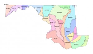
Twenty-four watersheds at the 8-Digit Hydrologic Unit Code (HUC) level are included or partially included in the State of Maryland.

Investigate the watersheds and their properties by clicking on the map.

NOTE: The clickable imagemap works as designed only on a large-screen device (desktop or laptop computer).

MD_watersheds

02040205, Brandywine-Christina 02050306, Lower Susquehanna 02050306, Lower Susquehanna 02060001, Upper Chesapeake Bay 02060002, Chester-Sassafras 02060003, Gunpowder-Patapsco 02060004, Severn 02060005, Choptank 02060006, Patuxent 02060007, Blackwater-Wicomico 02060008, Nanticoke 02060008, Nanticoke 02060009, Pocomoke 02060010, Chincoteague 02070002, North Branch Potomac 02070003, Cacapon-Town 02070004, Conococheague-Opequon 02070008, Middle Potomac-Catoctin 02070009, Monocacy 02070010, Middle Potomac-Anacostia-Occoquan 02070011, Lower Potomac 05020004, Cheat 05020006, Youghiogheny