Erika Crowl and Andrew Kness
University of Maryland Extension
Recent interest has been generated in using drones to seed cover crops into agronomic crops in small, irregularly shaped fields with rolling terrain or those fields otherwise not suitable for aerial seeding using a fixed-wing aircraft or helicopter. However, little is known about how effective drones are at seeding cover crops and if they can deliver seed at the appropriate rate to establish a sufficient cover crop. In order to evaluate cover crop stand establishment seeded via drones, we conducted an on-farm trial with support from the Maryland Soybean Board.
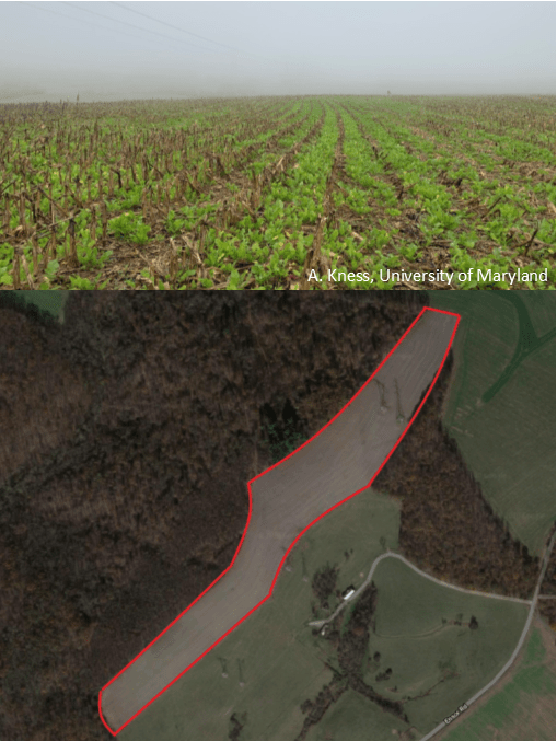
A cover crop of radish was flown on to a 26 acre standing corn field in Baltimore County, MD on August 27, 2020 at the rate of 16 pounds of pure live seed per acre using a HSE-TTA drone equipped with a spin spreader capable of carrying 40 lbs of seed. The field was an excellent candidate for this trial because of its irregular shape, rolling terrain, and close proximity to power lines and wood lines (Figure 1). Corn grain was harvested on September 15, 2020 and cover crop establishment was measured on October 21, 2020 by counting the number of radish plants per square foot in a one square foot area at 20 random locations across the field. The average cover crop plant population in the field was 3.1 plants/ft2, with a minimum of 0 and maximum of 6. Radish plants averaged 5 inches in height at the time of rating.
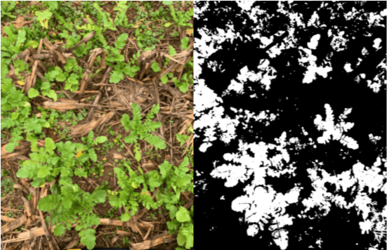
Canopy density was calculated using the Canopeo© application for smartphones (Oklahoma State University Department of Plant and Soil Sciences, Stillwater, OK; www.canopeoapp.com). Images were captured at 20 random locations across the field at a height of 2.5 feet above the ground and percentage green canopy was calculated by the Canopeo software (Figure 2). Average canopy coverage was 39.1%, with a minimum and maximum value of 20.3 and 53%, respectively.
Aerial establishment of cover crops is heavily influenced by soil moisture availability. August and early September saw sufficient rainfall in the region, contributing to conducive conditions for cover crop establishment. These data, representing only one field and one environment, demonstrate the potential that aerial seeding a radish cover crop with drones may be an effective method for establishing cover crops in these challenging fields. Future work will be done to replicate and gather additional data so that we can fully understand the feasibility of seeding cover crops with drones.
Acknowledgements: We would like to thank A-1 Aerials, K Drone Services, Graystone Farm, and the Maryland Soybean Board for supporting this work.
